Puno is a city in southeastern Peru, located on the shore of Lake Titicaca, the world’s highest navigable lake, at 3,860 m (12,421 ft) above sea level. It is also the capital and largest city of the Puno Region and the Puno Province.
Puno was the territory of the Tiahuanacos (800 A.D. – 1200 A.D.) who were the highest cultural expression of the Aymara people that established themselves in what is today Peru and Bolivia. The Incas took over these lands in the fifteenth century, and the Spanish, attracted by the mining industry developed there, left an important Colonial legacy throughout the entire area. The city, whose full name is San Carlos de Puno, was founded in 1668 following the discovery of nearby silver mines. Prior to this, Puno had been a small stopping off place between the much larger silver mines at Potosi in Bolivia and Lima.
Puno is, however, a melting pot of Indian cultures including the Aymara from the south and the Quechua from the north.
Today, the city of Puno (3,287 masl), which lies on the shores of Lake Titicaca, the highest navigable lake in the world, is the folklore capital of Peru and the site of the Feast of the Virgen de la Candelaria. In the outskirts, you can visit the spectacular Chullpas de Sillustani, a complex of impressive burial towers built by the Kollas, Juli, famous for its beautiful Colonial churches, Lampa with its vice royal church built between 1675 and 1685, Llachón, a community that still maintains its centuries old customs and cultural expressions, and Pucará, known for its pre-Inca pottery and for the “toritos de Pucará” that the artisans of today create from clay.
Puno´s Island
The lake contains numerous islands whose inhabitants continue to live as their ancestors have in custom and tradition. The Uros an example of this; this people group lives on “floating islands” that they have artificially made entirely of totora reeds, and they navigate in their traditional boats also made out of totora reeds. Taquile, Suasi, and Amantaní are knows for their kindness of their residents, their ancestral skill in weaving, their pre-Columbian constructions, and lovely countryside. The Titicaca National Reserve (36,180 hectares) protects extensive stretches of totora reeds and various species of plants and animals.
Agriculture
Puno is an important agricultural and livestock region; particularly of South American camelids (llamas and alpacas) which graze on its immense plateaus and plains. Many homes in Puno, much like surrounding cities, are half-finished. This is done so that the inhabitants do not have to pay taxes. Much of the city economy relies on the black market, fueled by cheap goods smuggled in from Bolivia. Puno has been designated to become a Special Economic Zone or “Zona Económica” by Peru’s president, Alan Garcia. Puno is served by the Inca Manco Capac International Airport in nearby Juliaca.
Puno’s geography and layout is unique, it is practically squeezed into the available land between the shores of Lake Titicaca and the small mountains surroudning the city. There is less than 2 miles distance of flat land between the shores and the foothills, which has caused the growing city to continue to expand upwards onto the hillsides, sprawling along every available, or nearly habitable plot of land on which a dwelling can possibly be built. As a result the town’s less developed and poorest areas, which are high on the hillsides, often have very steep street, which are generally not paved and cannot be accessed by automobile.
Altitude:
Capital: Puno (3827 masl / 12.553 fasl) Lowest point:820 masl / 2690 fasl (Lanlacuni Bajo) Highest point: 4725 masl / 15.498 fasl (San Antonio de Esquilache)
Climate:
The city of Puno is located on the shores of Lake Titicaca, and its climate is cold and semi-dry. The rainy season starts in October and ends in April. Its annual average maximum temperature is 14ºC (58ºF) and the minimum is 3ºC (37ºF).
TOURIST SITES OF PUNO
Titicaca National Reserve
This Protected Natural Area was created in 1978 in order to preserve the natural resources characteristic of Lake Titicaca and the highland ecosystem. It covers an area of 36.180 hectares. In the reserve, dozens of birds (over 60 species between resident and migratory birds), fish (4 different families) and amphibians (18 native species). Species have been registered like flamingos or parihuanas, Andean geese, seagulls, Titicaca grebes, chullumpis, and Andean lapwings as well as numerous endangered species. You will find twelve varieties of aquatic plants representative of the lake flora, the most remarkable being the totora reeds and algae.
TITICACA LAKE
 Lake Titicaca is the world’s highest navigable lake and the center of a region where thousands of subsistence farmers eke out a living fishing in its icy waters, growing potatoes in the rocky land at its edge or herding llama and alpaca at altitudes that leave Europeans and North Americans gasping for air. It is also where traces of the rich Indian past still stubbornly cling, resisting in past centuries the Spanish conquistadors’ aggressive campaign to erase Inca and preInca cultures and, in recent times, the lure of modernization.
Sillustani Burial Towers
Sillustani is located 35 km (21 miles) from Puno. Hundreds of years ago, the ancient people from the Altiplano, that lived at the shore of the mystical Lake Titicaca, built a series of funeral towers to bury their kings and other important people of their regions. Sillustani towers (which are up to 12 meters) A Spanish chronicle-keeper described them as “recently finished” in 1549, although some still appear as if they were never completed and the Indians that built them were conquered by the Incas about a century earlier.
The Sillustani towers are perhaps the finest and most perfect cylindrical constructions of ancient Peru, as such perfection can be found nowhere else in South America.
A tour to Sillustani will give you a better view into the life of pre-Inca civilizations, and exploring the area, you can marvel at the great beauty of the Umayo Lagoon, which is located at the foot of Sillustani.
The Island of Taquile
A much more interesting island to visit is Taquile, some 45 km from Puno, on which their are numerous pre-Inca and Inca ruins and Inca terracing; and was used as a prison during the Spanish Colony and well into the beginning of the 20th century. In 1970 it became property of the Taquile people The island is narrow, only about 1 km wide, and 6-7 km long. There is a cooperative shop on the island that sells exceptional woollen goods.
Taquiles have maintained their traditions and culture nearly unchanged for centuries, and are renowned in the area for their high-quality, colourful textiles. Furthermore, the Inca moral principles Ama Sua (Do not steal), Ama Quella (Do not lie), and Ama Lulla (Do not be lazy) are still observed by the inhabitants. Should one of the thousand plus inhabitants break these rules, the islands community authorities may even banish the lawbreaker as punishment.
The Island of The Uros
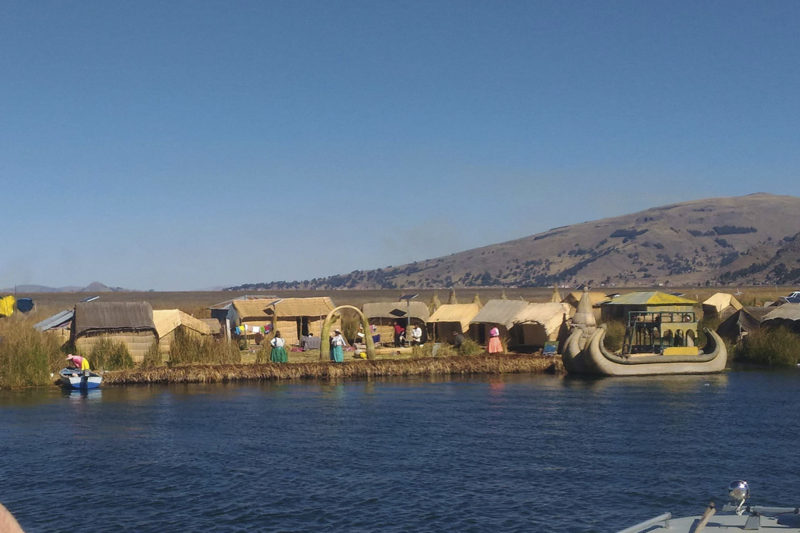 Although the Uros Indians of the floating islands have intermarried with Aymara Indians and no pure-blooded Uros exist, many of the inhabitants of the islands still practice the old traditions of fishing, trapping birds and living on the lake plants. The totora reeds which grow abundantly in the shallows of Lake Titicaca are used for their boats, houses and to build the very islands on which they live. The result is a strange springy surface which requires care when walking – it’s easy to put your foot straight through! This strange way of life began over 500 years ago when the Uros built the islands in an effort to isolate themselves from the Collas and the Incas.
The Legend say that the Uro Indians had black blood that helped them survive the frigid nights on the water and safeguarded them from drowning.
The Uros islands, are a group of 42 or so made of floating reeds (totora, a reed that abounds in the shallows of the lake). These islands have become a major tourist attraction for Peru, drawing excursions from the lakeside city of Puno. Their original purpose was defensive, and they could be moved if a threat arose. Many of the islands contain watchtowers largely constructed of reeds.
Wiñaymarca Archipelagoes – Anapia Island
At 128 km of Puno (2 hours and 30 minutes by car) we arrive in the town of Yunguyo from where it cabn be possible to continue driving until the port of Punta Hermosa (30 minutes). From this port until Anapia island there is 18 km of diatance (2 hours and 30 minutes by motor boat). Located in Lake Wiñaymarca or Minor lake of the set,the archipelagoes of islands is populated by people who conserve their native customs,between them, fishing is one fot he most important activities.
There are native flora throughout the region, abundant wildlife and beaches of sand and stone. The island Yuspique,’s largest archipelago, is used by the community of Anapia for breeding vicunas. You can appreciate crops, breeding vicunas and archaeological site all together with hiking activities, typical lunch, boating and folk music.
Cambria Comunnity and Suasi Islands
At 157 km to the northeast of Puno (3 hours and 30 minutes by car) we arrive in the town of Cambre which is located near Titicaca Lake, where you can share with the local farming, fishing operations and observe the work textile . In this community can be found transport services in rowing boats to access the island Suasi (20 minutes by boat approx.); which has built a shelter with materials from the area: stone, wood, straw and reeds; those is entirely supplied by solar energy. This island has 43 hectares, offers a variety of flora and fauna. Here you can observe herbs, medicinal, natural grasses, shrubs and trees. In the area of protection of wild birds, there are Chocco, cormorants, ducks, zambullidores, hummingbirds, face sides, mandolas, among others. Besides, there are vicunas and vizcachas modules and potato crops, geese, quinoa, corn and tarwi too.
Isla de Amantani
Amantani, a lovely and peaceful island even further away from Puno than Taquile. is another small island on Lake Titicaca populated by Quechua speakers. About 800 families live in six villages on the roughly circular 15 square kilometres (6 sq mi) island. There are two mountain peaks, called Pachatata (Father Earth) and Pachamama (Mother Earth), and ancient ruins on the top of both peaks. Amantani was once part of the Inca empire, as attested to by local ruins, before the Spanish invaded and slaughtered the islanders. The Spaniard who was granted a concession to the island used the Indians in forced labor and his descendants were still in control after Peru’s independence from Spain.
Amantani has opened its doors to outsiders who are willing to live for a few days as the Aymará-speaking islanders do -and that means sleeping on beds made of long hard reeds and eating potatoes for every meal. The people maintained the same traditions for centuries. Some Amantaní residents live and die without ever leaving the island.
The residents make beautiful textiles and sell them quite cheaply at the Artensania Cooperative. The people are Quechua speakers, but understand Spanish.
Juli
Located at 79 km of the south of Puno (1 hour and 20 minutes by car). This village was founded by the Dominicans in 1534, but later they were expelled by the missionary congregation of the Jesuits, which was established in Juli during the viceroyalty, where priests turned the town into a strategic center to prepare missionaries to Paraguay and Bolivia.
Known as the “Little Rome of americas” due to its temples, churches stand out in Juli such as St. John Lateran, St. Peter Martyr and Holy Cross of Jerusalem, and also the House of the Inquisition or Zavala. Inside the churches can be seen stone sculptures, wood carvings, paintings and oil paintings produced by prominent artists such as the Jesuit Bernardo Bitti.
Kalasaya
Located at 1 km from the town of Pucara (5 minutes by car). A ceremonial centre belong to the Pucaras culture , built around the year 200 BC, reached its peak between the years 250 BC and 380 A.D. There are two areas: an area composed by nine ceremonial pyramids and other urban one.
Lampa
Located at 80 km of the north of Puno (1 hour and 30 minutes by car). Lampa is the capital of the province and is well-known as the “pink city” because of the color of its walls. In the area there are large forest of queñua, Puy de raimondi and breeding places of chinchillas, among other attractions.
Pomata
In Pomata there are plenty of attractions such as the church of Santiago Apostol,which has a mixed style ,and the incredible panoramic view of the lake and the peninsula of Copacabana.
Pucará
Located at 106 km to the north of Puno (1 hour, 45 minutes by car). The town of Pucara is famous for its pottery, especially for its famous “toritos of Pucara,” and there is a Museum of Lithics Pucara, which displays a set of stone sculptures such as monoliths, steles and zoomorphic sculptures, ceramics and other objects as well.